Commissions

How It Works
As part of my work I take on commissions to map your country. This involves a number of site visits and collaboration to ensure we are both on the same page regarding what is wanted. Besides topography, watersheds, soaks, creeks and larger natural features, the map is greatly affected by the seasons, the colours, shades and shapes, the pathways of animals, the sounds and flora, the prevailing winds, the interactions and movements of the owners upon the land, and many other variables My maps are absolutely unique to the place, an attempt to capture your country as an artistic expression, a moment.
Commissions Story
Sevens Creek Commission
Yerim Commission
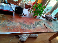
This is a commission for a 3 km stretch of the Sevens Creek. It is a spectacular piece of water that drops off about 150 metres from the Strathbogie plateau. The map was made in winter when the waters were running really hard. On a couple days the access was quite limited.

At an early point in the making of this map I really wanted to allow the 'creatureliness' of the river to show itself. I declined to use any aerial imagery, simply allowing what spoke to me at ground level to speak out loudly.

About eight visits were made recording the creek and surrounds on A4 paper, first in pencil and then in fine liner ink. I would walk ten paces along the bank and record what I saw, rocks, pools, waterfalls, topography etc. No vegetation was recorded on this map apart from reed beds on the creek.

This is a commission for a wetland trust for nature property, about 6 acres in size, it comprises a perched sphagnum bog and dense tea tree thicket that runs into the Magiltan Creek in Strathbogie. The vegetation is mainly Swamp Gums, Small leaf peppermints and Blackwoods.

What became striking is the Wombat and Swamp Wallaby paths that criss-cross the country, pathways dissecting and creating a whole different level to the map.
The map was created on 5 separate A3 watercolor pages, And was slowly walked over a four week period, penciling every detail. This was then outlined with a fine liner pen.


Next the printer was engaged and he put them together and printed them as a whole piece, measuring 2100 mm in length, this was printed as an edition of 5.
The 9 separate A4 sheets were then sent to the printer who joined them up into one piece of 1850 mm. The final colour scheme became a collaboration between Guy and Catherine who commissioned the map and myself.

All pieces are then hand colored.
